Thornton to Firestone Gravel Ride
Elapsed Time: 2:45
Average Speed: 10.9 mph
Top Speed: 25.6 mph
Distance: 30 miles
Start/Stop Location: Springvale Park Disk Golf Course, Thornton, CO
Total Ascent: 894 feet
Max Positive Grade: 3.3%
Max Negative Grade: -3.3%
Road Surface: 30% paved, 70% gravel
Hazards:
A narrow shoulder with moderate traffic along Holly Street in Thornton. Loose dogs.
Description:
This ride follows gravel county roads between north Thornton and the eastern flank of Fredrick and Firestone. Hills are short with easy grades and the views are open with few obstructions to obscure oncoming traffic. The most challenging aspect of this ride is the occasional patch of deep gravel. The 2” wide tires on my Raleigh Stuntman handled these sections with aplomb.
Beware of loose dogs. Most homes along the way with dogs had them fenced-in but I did encounter one aggressive Chihuahua that managed to keep pace with me as I attempted to accelerate away from him. If he had been more than 10 inches tall this would’ve been a problem.
Northern Adams County and Southern Weld County are oil and gas country. Expect to see a lot of energy infrastructure and an occasional fracking truck.
Directions:
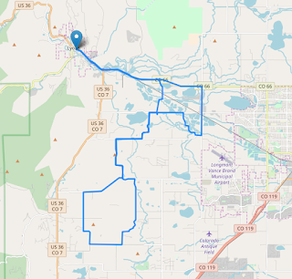
Start from the parking lot of the Springvale Park Disc Golf Course near 136th and Holly Streets in Thornton and head north along Holly. The road alternates between blacktop and hard pack gravel until the jog left onto CO-15 at 168th where the surface remains gravel for almost its entire length to CO-18 near Firestone. Hang a right on CO-18 and continue to CO-21 and make another right turn. Follow CO-21 to CO-6 and make a right until you arrive back at CO-15 where a left turn leads back to Thornton.
Map:

Elapsed Time: 2:45
Average Speed: 10.9 mph
Top Speed: 25.6 mph
Distance: 30 miles
Start/Stop Location: Springvale Park Disk Golf Course, Thornton, CO
Total Ascent: 894 feet
Max Positive Grade: 3.3%
Max Negative Grade: -3.3%
Road Surface: 30% paved, 70% gravel
Hazards:
A narrow shoulder with moderate traffic along Holly Street in Thornton. Loose dogs.
Description:
This ride follows gravel county roads between north Thornton and the eastern flank of Fredrick and Firestone. Hills are short with easy grades and the views are open with few obstructions to obscure oncoming traffic. The most challenging aspect of this ride is the occasional patch of deep gravel. The 2” wide tires on my Raleigh Stuntman handled these sections with aplomb.
Beware of loose dogs. Most homes along the way with dogs had them fenced-in but I did encounter one aggressive Chihuahua that managed to keep pace with me as I attempted to accelerate away from him. If he had been more than 10 inches tall this would’ve been a problem.
Northern Adams County and Southern Weld County are oil and gas country. Expect to see a lot of energy infrastructure and an occasional fracking truck.
Directions:
Start from the parking lot of the Springvale Park Disc Golf Course near 136th and Holly Streets in Thornton and head north along Holly. The road alternates between blacktop and hard pack gravel until the jog left onto CO-15 at 168th where the surface remains gravel for almost its entire length to CO-18 near Firestone. Hang a right on CO-18 and continue to CO-21 and make another right turn. Follow CO-21 to CO-6 and make a right until you arrive back at CO-15 where a left turn leads back to Thornton.
Map:


Comments
Post a Comment