Posts

Old Man Winter Rally 50K

Image
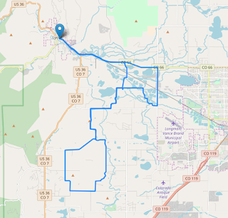
Elapsed Time: 4 hours Average Speed: 7.9 mph Max Speed: 28.7 mph Distance: 31.7 miles Start/Stop Location: Sandstone Park, Lyons, CO Total Ascent: 1164 feet Max Positive Grade: 4.6% Max Negative Grade: -5.1% Road Surface: 40% paved, 60% gravel Hazards: Multiple transitions from gravel to blacktop and back.  Narrow shoulders on blacktop. Description: This was an organized ride with 100+ riders.  It was a cold day for a ride.  The temperature at the noon start was 32F and four hours later it was still 32F.  The previous day had seen about four inches of snow which started to melt into slush about half way through the ride.  A slight breeze, cloud cover for most of the ride, high humidity, and freezing spray from the road contributed to a significant amount of discomfort.  This was especially true for the last 10 miles of the ride. Aside from the difficult riding conditions, this ride did not present challenging terrain and traffic was almost non existent except for the
Image
Thornton to Firestone Gravel Ride Elapsed Time: 2:45 Average Speed: 10.9 mph Top Speed: 25.6 mph Distance: 30 miles Start/Stop Location: Springvale Park Disk Golf Course, Thornton, CO Total Ascent: 894 feet Max Positive Grade: 3.3% Max Negative Grade: -3.3% Road Surface: 30% paved, 70% gravel Hazards: A narrow shoulder with moderate traffic along Holly Street in Thornton.  Loose dogs. Description: This ride follows gravel county roads between north Thornton and the eastern flank of Fredrick and Firestone.  Hills are short with easy grades and the views are open with few obstructions to obscure oncoming traffic.  The most challenging aspect of this ride is the occasional patch of deep gravel.  The 2” wide tires on my Raleigh Stuntman handled these sections with aplomb. Beware of loose dogs.  Most homes along the way with dogs had them fenced-in but I did encounter one aggressive Chihuahua that managed to keep pace with me as I attempted to accelerate away from him.  
Image
Poorman Road Gravel Ride Elapsed Time: 2:08 Average Speed: 10.3 mph Top Speed: 42.6 mph Distance: 22 miles Start/Stop Location: East Boulder Community Center Total Ascent: 1333 feet Max Positive Grade: 11.5% Max Negative Grade: -8.9% Road Surface: 90% paved, 10% gravel Hazards: Low bridges and blind curves on the Boulder Creek path, pedestrians, no shoulders in Four Mile Canyon, washboards in a curve on Poorman Road, steep high-speed descent with hairpin turns through Sunshine Canyon. Description: This ride combines urban trails and steep gravel for an easy ride with short sections that require serious effort. The first eight miles meander along neighborhood streets and paved recreational paths. A slow pace and cautious riding through throngs of enthusiastic cyclists, runners, and tourists dominate the landscape until the path begins its climb into Boulder Canyon. As the path leaves town, the grade increases to a moderate incline. Turning onto Four Mile Canyon doesn’t