Poorman Road Gravel Ride
Elapsed Time: 2:08
Average Speed: 10.3 mph
Top Speed: 42.6 mph
Distance: 22 miles
Start/Stop Location: East Boulder Community Center
Total Ascent: 1333 feet
Max Positive Grade: 11.5%
Max Negative Grade: -8.9%
Road Surface: 90% paved, 10% gravel
Hazards:
Low bridges and blind curves on the Boulder Creek path, pedestrians, no shoulders in Four Mile Canyon, washboards in a curve on Poorman Road, steep high-speed descent with hairpin turns through Sunshine Canyon.
Description:
This ride combines urban trails and steep gravel for an easy ride with short sections that require serious effort. The first eight miles meander along neighborhood streets and paved recreational paths. A slow pace and cautious riding through throngs of enthusiastic cyclists, runners, and tourists dominate the landscape until the path begins its climb into Boulder Canyon. As the path leaves town, the grade increases to a moderate incline. Turning onto Four Mile Canyon doesn’t increase the grade but the open road offers the opportunity to stand up and crank. After two miles of blacktop, the right turn onto Poorman Road yields real Colorado mountain steeps. Immediately after turning off of Four Mile Canyon Road, Poorman Road gains 400 feet in less than a mile with grades approaching 12%. Passing the intersection with Leonards Road, after 0.8 miles of steep gravel, brings relief as the grade returns to near-level. A mild descent on gravel then leads to increased speed through a curve containing noticeable washboards. Turning off of Poorman Road, the 9% downgrade in Sunshine Canyon combines high speeds and hairpin turns where the possibility for overspeed and rocks in the road could spell trouble. Car doors, people, and dogs are present adjacent to access points for Mount Sanitas just before entering Boulder city limits. Views on this ride are spectacular and encountering other cyclists is likely. The “Poorman Loop” is well known among locals.
Directions:
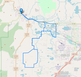
Start from the parking lot at the East Boulder Community Center. Pick up the South Boulder Creek trail at the NE corner of the parking lot and head north for about half a mile. Cross over Baseline Road and continue north on Gapter Road for one block and turn left onto the multi-use path. Follow the path to the fork and veer left. Continue on the path past the golf course on the right and under 55th Street, turning right after emerging from the viaduct. Turn south on the sidewalk along 55th street to Pennsylvania Avenue and make a right. As Pennsylvania Avenue turns right into Eisenhower Drive another path starts to the left. Turn here and follow the path up and over the concrete overpass at Foothills Parkway. Continue west on the path until the right turn onto the Skunk Creek path. Continue north under Colorado Avenue and through the CU Boulder East Campus. The Skunk Creek path ends 0.5 miles past Colorado Avenue at the Boulder Creek path. Turn left and follow the Boulder Creek path all the way to its western terminus at the intersection of CO-119 and Four Mile Canyon Drive. Continue 1.8 miles up Four Mile Canyon Drive and hang a right on Poorman Road. Follow Poorman Road 1.5 miles until it ends at Sunshine Canyon Drive and turn right. Sunshine Canyon Drive continues as Mapleton Avenue in Boulder. Turn right at some point and head south back to the Boulder Creek path for the return ride. Retrace the route to get back to the East Boulder Community Center.
Map:

Elapsed Time: 2:08
Average Speed: 10.3 mph
Top Speed: 42.6 mph
Distance: 22 miles
Start/Stop Location: East Boulder Community Center
Total Ascent: 1333 feet
Max Positive Grade: 11.5%
Max Negative Grade: -8.9%
Road Surface: 90% paved, 10% gravel
Hazards:
Low bridges and blind curves on the Boulder Creek path, pedestrians, no shoulders in Four Mile Canyon, washboards in a curve on Poorman Road, steep high-speed descent with hairpin turns through Sunshine Canyon.
Description:
This ride combines urban trails and steep gravel for an easy ride with short sections that require serious effort. The first eight miles meander along neighborhood streets and paved recreational paths. A slow pace and cautious riding through throngs of enthusiastic cyclists, runners, and tourists dominate the landscape until the path begins its climb into Boulder Canyon. As the path leaves town, the grade increases to a moderate incline. Turning onto Four Mile Canyon doesn’t increase the grade but the open road offers the opportunity to stand up and crank. After two miles of blacktop, the right turn onto Poorman Road yields real Colorado mountain steeps. Immediately after turning off of Four Mile Canyon Road, Poorman Road gains 400 feet in less than a mile with grades approaching 12%. Passing the intersection with Leonards Road, after 0.8 miles of steep gravel, brings relief as the grade returns to near-level. A mild descent on gravel then leads to increased speed through a curve containing noticeable washboards. Turning off of Poorman Road, the 9% downgrade in Sunshine Canyon combines high speeds and hairpin turns where the possibility for overspeed and rocks in the road could spell trouble. Car doors, people, and dogs are present adjacent to access points for Mount Sanitas just before entering Boulder city limits. Views on this ride are spectacular and encountering other cyclists is likely. The “Poorman Loop” is well known among locals.
Directions:
Start from the parking lot at the East Boulder Community Center. Pick up the South Boulder Creek trail at the NE corner of the parking lot and head north for about half a mile. Cross over Baseline Road and continue north on Gapter Road for one block and turn left onto the multi-use path. Follow the path to the fork and veer left. Continue on the path past the golf course on the right and under 55th Street, turning right after emerging from the viaduct. Turn south on the sidewalk along 55th street to Pennsylvania Avenue and make a right. As Pennsylvania Avenue turns right into Eisenhower Drive another path starts to the left. Turn here and follow the path up and over the concrete overpass at Foothills Parkway. Continue west on the path until the right turn onto the Skunk Creek path. Continue north under Colorado Avenue and through the CU Boulder East Campus. The Skunk Creek path ends 0.5 miles past Colorado Avenue at the Boulder Creek path. Turn left and follow the Boulder Creek path all the way to its western terminus at the intersection of CO-119 and Four Mile Canyon Drive. Continue 1.8 miles up Four Mile Canyon Drive and hang a right on Poorman Road. Follow Poorman Road 1.5 miles until it ends at Sunshine Canyon Drive and turn right. Sunshine Canyon Drive continues as Mapleton Avenue in Boulder. Turn right at some point and head south back to the Boulder Creek path for the return ride. Retrace the route to get back to the East Boulder Community Center.
Map:


Comments
Post a Comment